Beneath Oshawa's post-glacial landscape, the contact between dense Halton Till and the underlying Ordovician limestone of the Lindsay Formation presents a sharp acoustic impedance contrast that makes the city's subsurface particularly well-suited for seismic tomography investigations. As the city expands northward into terrain that once hosted drumlin fields and ice-marginal deposits, accurately mapping bedrock depth and identifying potential karst dissolution features becomes critical before committing to foundation design. Seismic tomography—both refraction and reflection—offers a continuous image of the subsurface that point-source tests cannot provide, revealing velocity variations that correlate with changes in material stiffness, degree of fracturing, and water saturation. The method has proven especially valuable across Durham Region, where till thickness can vary from less than two metres to over thirty metres within a single property boundary, a variability that surprises many developers accustomed to working on the more uniform soils south of the Oak Ridges Moraine. Our team deploys 24- or 48-channel seismographs with high-frequency geophones to capture detailed P-wave and S-wave velocity profiles, processing the data with tomographic inversion algorithms that honor the curved ray paths characteristic of heterogeneous glacial sequences. For projects where bedrock rippability must be assessed, we often combine the seismic survey with a targeted CPT test program to calibrate velocity-to-strength correlations against direct penetration resistance measurements, ensuring that excavation planning is grounded in site-specific data rather than regional generalizations alone.
Tomographic inversion reveals velocity gradients within the Halton Till that correlate directly with changes in preconsolidation pressure and bearing capacity, information no discrete borehole alone can capture.
Our approach and scope
Local ground factors
Oshawa sits within the western Lake Ontario seismic zone, and while large-magnitude events are less frequent than in other parts of the country, the 2020 National Building Code of Canada assigns the city a seismic hazard value that demands rigorous site classification per NBCC Table 4.1.8.4.A. The real risk, however, is not just the ground motion itself but the amplification effects that can occur when loose lacustrine silts—mapped extensively along the former shoreline of glacial Lake Iroquois—overlie more competent till at depths of five to fifteen metres. Seismic tomography directly measures the shear-wave velocity profile needed to compute the average Vs30 for site classification, eliminating the reliance on generic correlations between SPT N-values and shear-wave velocity that often carry uncertainties of thirty percent or more. A site incorrectly classified as Class C when it should be Class D or E can result in structural under-design, while the opposite error leads to unnecessary construction costs. By integrating the tomographic results with slope stability analysis for sites adjacent to Oshawa Creek and its tributary ravines, we help project owners manage the compound risk of seismic shaking and slope deformation in a single, coherent ground model.
Regulatory framework
National Building Code of Canada (NBCC) 2020, Division B, Part 4, CSA A23.3:19 - Design of Concrete Structures (seismic provisions), ASTM D5777-18 - Standard Guide for Using the Seismic Refraction Method, ASTM D7128-18 - Standard Guide for Using the Seismic Reflection Method, Canadian Foundation Engineering Manual (CFEM) 4th Edition
Other technical services
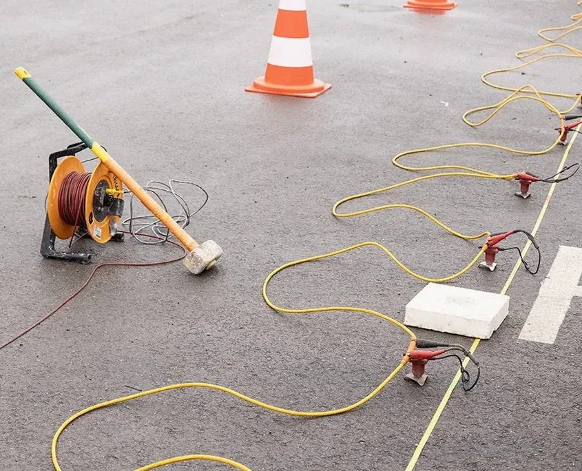
Combined Seismic Refraction and MASW Survey
A single geophone spread simultaneously records both P-wave refraction data and surface wave data for MASW processing. This approach delivers a complete compressional and shear-wave velocity profile from one mobilization, enabling seismic site classification per NBCC and bedrock mapping in a single field campaign. Delivery includes 2D velocity tomograms, interpreted geological cross-sections, and a formal site classification letter signed by a professional geoscientist licensed in Ontario.
High-Resolution Reflection Tomography for Infrastructure Corridors
For linear projects such as pipeline alignments, road widenings, and watermain trenching through Oshawa's older neighborhoods, we configure a rolling spread of closely spaced geophones with a high-frequency source to image the overburden-bedrock interface and any intra-overburden reflectors at sub-metre vertical resolution. The method excels at detecting abrupt changes in till thickness and identifying buried valleys that could impact trench stability and dewatering design.
Typical parameters
Common questions
What is the typical cost range for a seismic tomography survey in Oshawa?
For most projects in the Oshawa area, seismic tomography investigations fall within a range of CA$4,260 to CA$8,090, depending on the total linear metres of profile, the number of spreads required, and whether the scope includes both refraction and reflection acquisition. Projects with extended spreads for deep bedrock mapping or those requiring full-waveform inversion processing will trend toward the upper end of the range. Each proposal is priced based on site-specific logistics and the investigation depth required.
How does seismic tomography differ from a standard seismic refraction survey?
Standard seismic refraction interpretation uses a layered model that assumes discrete, planar interfaces between materials of constant velocity. Tomographic inversion abandons this layered assumption and instead divides the subsurface into a grid of small cells, iteratively adjusting the velocity of each cell until the calculated travel times match the measured data. The result is a continuous velocity image that can reveal lateral velocity gradients, embedded low-velocity zones, and irregular bedrock topography—features that a layered interpretation would either miss or misrepresent.
Can seismic tomography detect voids or cavities in the limestone beneath Oshawa?
Yes, with appropriate survey design. The Lindsay Formation limestone underlying the Oshawa area is known to contain dissolution features and occasional karst cavities. A void or air-filled cavity appears as a localized low-velocity anomaly on a refraction tomogram, and as a high-amplitude diffraction on a reflection record. Detection sensitivity depends on the cavity size relative to its depth and the geophone spacing; we typically tighten the receiver interval to two metres or less when cavity detection is a primary objective.
What surface conditions can interfere with seismic tomography data quality?
In Oshawa's urban and suburban environment, the most common challenges are traffic vibration, buried utilities, and areas of asphalt or concrete pavement. Traffic noise can be mitigated by scheduling acquisition during low-traffic periods and using signal stacking. Pavement generally improves source coupling but can create a high-velocity surface layer that complicates refraction interpretation if not properly modeled in the starting velocity model. Buried metallic utilities may introduce electrical noise on some geophone types, though modern shielded cabling largely eliminates this issue.
How long does a typical seismic tomography survey take, and when do we receive results?
Field acquisition for a single 115-metre spread with a four-person crew typically requires one day, including setup, shooting, and demobilization. Larger projects involving multiple spreads or reflection acquisition may extend to two or three days in the field. Preliminary velocity tomograms are usually available within three to five business days after acquisition, with the final interpreted report—including geological cross-sections and engineering commentary—delivered within ten business days. Expedited turnaround can be arranged when project schedules demand it.